


I. Smart Cities
Forbes defines Smart Cities as cities that “apply the latest generation of data-driven analytics to develop software that provides the insight, agility, and automation to help coordinate city management efforts and streamline delivery of services – during everyday operations as well as emergencies.”
Technology has been rapidly evolving, transforming all U.S. cities, where you can get the weather, know the traffic, get community alerts, and find the most accessible transportation routes through one device: your smartphone.
Technology, application, and usage are essential to creating a smart city with the rise of Artificial Intelligence.
Ten Characteristics of a Smart City
- Uses data to deliver city services based on where and when they can do the most good.
- It creates digital platforms that allow it to use Internet of Things (IoT) data to improve how it builds, maintains, and uses physical infrastructure. (The amount of its IoT data does not define a smart city but rather by its use, how it analyzes and uses the data to improve the quality of life and safety)
- Makes public employees smarter in their work.
- Enhances the way it listens to and involves the public.
- Uses digital tools to operate more equitably.
- Addresses sustainability and resiliency.
- Protects privacy, security, and transparency.
- Acts in real-time.
- Focuses on its residents.
- Adopts a new culture and organization.
Links of Interest:
- As the Chorus of Dumb City Advocates Increases, How Do We Define the Truly Smart City?
- https://datasmart.hks.harvard.edu/chorus-dumb-city-advocates-increases-how-do-we-define-truly-smart-city
- Can a machine write a zoning code
- Are we close to automating zoning?
II. Battery storage facilities
A battery energy storage system (BESS) is an electrochemical device that collects energy from the grid or a power plant. Then it discharges that energy later to provide electricity when needed.
Different grid-scale applications include lithium-ion, lead-acid, redox flow, and molten salt (including sodium-based chemistries).
The current market for grid-scale battery storage in the United States and globally is dominated by lithium-ion batteries, which are cheaper now due to technological innovations and improved manufacturing capacity.
Talking Points with BESS representatives:
- They will need an Ohio Certificate of Environmental Compatibility and Public Need.
- Currently In Ohio, such a certificate is for Energy Generation only, not for Energy Storage (but OPSB is still issuing them based on its interpretation of the law).
- The facility must be in the public interest and for general convenience and necessity.
- Even if it’s a “public utility,” a Zoning Certificate may still be needed.
- You may have a right to have a local representative on the Ohio Power and Siting Board Committee.
- May need a Road Maintenance Agreement. The county/Township may be able to set up restrictive areas (Ohio Substitute Senate Bill 52)
- Get a Decommissioning Plan and Bonding
- Eligible for funds for Fire Training
- Battery Storage Facilities Map and Statistics (Ohio Power Siting Board)
- Ohio Power Siting Board approves state’s first grid-scale battery storage project
III. eVTOL Electric Vertical Takeoff and Landing
- Take off like a helicopter but fly like an airplane; have multiple rotors; Most electrical (some hybrids)
- Commercial operations in 2025: $6.9 Billion in 2021, $30 billion in 2031
- Use low-altitude air corridors
- Flown by the pilot in person or remotely, most will be autonomous in the future
- Low cost, quiet, low carbon impact, take off/land in a small area
Links of interest:
- Joby Selects Dayton, Ohio, Birthplace of Aviation, For First Scaled Manufacturing Facility
- ‘We’d like you to build it here.’ How Dayton and Ohio won Joby Aviation’s historic eVTOL plant How Dayton and Ohio advocates came together to make aviation history
- Joby Announces Scaled eVTOL Factory in Dayton, Ohio
IV. Federal law preemption
- A.A. jurisdiction is generally over 700 feet (pushing for “above the grass”)
- Ground Location is local; Air space is federal or state. Air space rules vary by location.
- FAA Air Space Jurisdiction
V. ITS NOT JUST AN URBAN THING…
Ohio University and the Ohio Department of Transportation are working to help Appalachian communities prepare and explore opportunities for the region’s business, transportation, medical, and logistical needs.
“The ease of use and expansion of access that we may be able to experience in the next 10-20 years due to this innovation in transportation could be life-changing, especially to those in rural areas like Southeastern Ohio…there are 27 general aviation airports in the 32 Appalachian counties actively supporting commercial, personal, government, and business use. Capitalizing on next-generation aviation would leverage these airports for new economic and community development beneficial to rural Ohio.
VI. Ohio Aggressively moving to eVTOL
In 2022, Ohio released the nation’s first Advance Air Mobility statewide framework through the Ohio Department of Transportation/ DriveOhio,
Ohio’s advanced air mobility framework captures the advanced aviation ecosystem, Ohio-specific activities, route planning considerations, and recommendations for vertiport establishment. It provides a strategic map for Ohio to support this emerging industry. “Three use cases that have the potential to drive transportation efficiency and support a robust new aerospace industry in the State of Ohio are:
Cargo / Freight Delivery: Transportation of heavy cargo, freight, small packages, and on-demand commerce from or between airports, distribution centers, manufacturers, and retailers to consumers. Logistics transportation and e-commerce can realize significant efficiencies by leveraging advanced aircraft.
Regional Air Mobility: Regularly scheduled or on-demand transportation between cities more than 50–75 miles apart. Numerous studies found that using advanced aviation by air for short intra-regional trips (from one city center to another nearby city center or city center to a rural area) can save time.
Emergency Services: Advanced air mobility vehicles can facilitate an innovative medical services transportation system, including emergency medical evacuations, hospital-to-hospital patient and equipment transportation, organ delivery, and search-and-rescue operations.”
VII. Vertiports
A. NASA Study
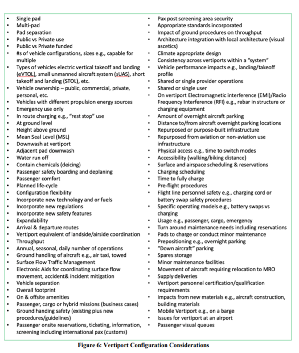
Figure 6 from NASA Advanced Air Mobility Vertiport Considerations: A List and Overview
B. Vertiport Planning Considerations
- Environmental Impacts: Noise, Light and Vibration, Migratory Patterns, Dust.
- Land Use: Property rights, compatibility, and visual noise.
- Connectivity Required: needs to integrate with surrounding public transport services
- Utilities: electrical connections; fiber.
- Viable site location depends on the eVTOL use (commuter, airport shuttle, points-of-interest, cargo, emergency, etc.)
- Military Air Space, No fly Zones (prisons), Airspace classification,
- Best location: open field with no airspace restrictions in a dense urban area near other modes of transport with considerable electrical power present. Does this exist?
- Existing airports, Heliports, or Rooftops, Industrial land, City fringe, and Regional Destinations,
- City rooftops unlikely for some time: hard to get approval, logistics and safety issues of operating in dense urban environments, fire codes, bringing passengers from the ground level to the roof
- Retrofitting the building is unlikely: it is not structurally designed for weight, and the need to bring the entire building to current code,
C. FAA and Vertiports
2022 FAA Vertiport Design Guidelines
- Geospatial: Dimensions for vertiport touchdown and liftoff areas, additional airspace for approach and departure paths, and load-bearing capacity.
- Lighting: Lighting, markings, and visual aids: Guidelines on markings, lighting, and visual aids that identify the facility as a vertiport. The FAA recommends the Vertiport Identification Symbol, as shown in the middle of the graphic below.
- Charging and electric infrastructure: Initial safety standards and guidelines for batteries and charging equipment that will be central to vertiports.
- On-airport vertiports: Requirements for airports looking to add vertiports to an existing commercial airport, including the distance a vertiport would have to be from a current runway.
- Elevated vertiports: Requirements and guidelines for vertiports that may be on top of existing structures.
D. Vertiport Safety
New safety protocols will need to be developed.
Currently, licensed airfields seeking to integrate eVTOLs into their operations should update their existing plans due to batteries stored on-site.
FAA recommends that local governments have zoning protections to protect airspace in and around vertiports. Localized (non-standardized) approaches create less certainty for infrastructure developers across broad operational areas.
Industry stakeholders must work with local regulators on zoning and other regulatory requirements to secure investment, obtain permits (including conditional use as applicable), and begin constructing new facilities.
E. State and Local Government Role in Vertiport Development
FAA recommends that local governments have zoning protections to protect airspace in and around vertiports.
Localized (non-standardized) approaches create less certainty for infrastructure developers across broad operational areas.
Industry stakeholders must work with local regulators on zoning and other regulatory requirements to secure investment, obtain permits (including conditional use as applicable), and begin constructing new facilities.
F. Local air traffic control
Drone industry technologies have a ground-based detect and avoid a system that can track drones and keep them from colliding with each other, as well as aircraft that operate at lower altitudes, like medical helicopters or crop dusters.
VIII DRONES
- FAA Drone Regulations
- https://www.faa.gov/uas
- Use in urban planning.
- Use in zoning violations (privacy and 4th amendment issues)
A means of delivering packages and other retail items to customers on small to medium-sized drones
It was created to be more efficient than mail services such as regular mail and FedEx. It is also known to be able to get to harder-to-deliver places.
Examples:
Prime Air integrates drone deliveries and boasts of same-day delivery for thousands of items weighing five pounds or less. The U.K., Italy, California, and Texas (did not quite fulfill the projected goals partly due to the issue of needing help to secure regulatory approval). However, the first company to operate a drone was more significant than 55 pounds.
U.P.S. Flight Forward – aimed to deliver small packages beyond visual line of sight, uses Matternet M2 drones
Wing – Partnership with Walmart and a drone delivery provider powered by Google’s parent company, Alphabet. Dallas/Fort Worth, Texas, users can order items from the Wing Drone Delivery App.
Zipline International, Inc.: Deliver packages around Salt Lake City that fly beyond the operator’s visual line of sight.
FAA Regulations and Other Issues
- FAA, Part 135
- Certification is the only path for small drones to carry the property of another for compensation beyond visual line of sight.
- 14 CFR 135 (Code of Federal Regulations) federal sovereignty over American airspace and federal preemption of aviation safety regulations do not preclude state and local regulation of non-federal aspects of aviation. This principle also applies to drones. As long as the focus of a law or regulation is not an aspect of aviation that the F.A.A. actively controls (and not an aviation-related area pre-empted explicitly by federal statutes, such as noise limits), there is plenty of room for state and local exercise of police powers.
- Ohio Bar Drones and the Law: What You Need to Know
Current City Regulations on Drones
- Must follow F.A.A. rules
- R.C. 122.98 created the Ohio Aerospace and Aviation Technology Committee for research purposes.
- Several municipal parks have prohibited flying drones (Lorain, Toledo, Butler County).
- The City of Celina has banned drones in airspace over all city-owned property.
- Cleveland allows police to enforce F.A.A. rules on drones
- Other cities limit drones without written permission of officials (Cincy, Butler County Metro Park
Localities and Zoning for Drones cont.
- Issues for city planners to focus on:
- Current Zoning Regulations: How do local zoning laws and regulations accommodate delivery drones?
- Landing Issues: Where should drones land, and how far above ground should they be?
- Noise and Environmental Impact
- Community support and division over new technology and its placement
IX Artificial Intelligence (AI)
- Writing zoning codes
- Chat GPT
Provides a computer program to have certain humanlike qualities, which include adapting and growing in thought and deciding in algorithms
OpenAI’s ChatGPT is the latest technology, known as a large language model.
ChatGPT allows you to place a prompt, and the app generates a response.
An infamous example was when lawyers used ChatGPT without checking the sources, and ChatGPT made up cases that the judge discovered.
Sources state that ChatGPT will likely not be able to replace the need for city planners as zoning is an intensive and complex task with several legal documents and variables a software cannot all understand
However, it may be helpful as a brainstorming tool or a problem-solving device.
For example, if you have a problem, need a solution, and have variables, you can add to the prompts and try to generate a solution with AI.
Let the Robots write the ordinance
Will ChatGPT Replace Your City’s Zoning Department? Here’s Why We Say No.
*EXAMPLE OF AI ANSWER TO CAN AI DRAFT A VERTIPORT ZONING ORDINANCE
“Drafting a proposed zoning ordinance for airplane taxis in a mid-sized city is a complex and highly specialized task requiring input from legal experts, urban planners, aviation authorities, and local government officials. It’s not something that can be provided in a simple text response.
However, I can provide you with a basic outline of key considerations to include in such an ordinance:
- Zoning Districts: – Define specific zoning districts where airplane taxi operations are permitted, such as commercial, industrial, or airport-related zones.
- Land Use Permissions: – Specify the types of land uses related to airplane taxi operations, including takeoff and landing areas, maintenance facilities, and passenger terminals.
- Height Restrictions: – Establish height restrictions to ensure the safety of aircraft taking off and landing and prevent interference with other structures or airspaces.
- Noise Regulations: – Set noise regulations to limit the impact of airplane taxi operations on surrounding neighborhoods and businesses.
- Safety and Security: – Outline safety and security measures, including fencing, access control, and emergency response plans.
- Environmental Impact: – Address potential environmental impacts, such as emissions, and require operators to adhere to environmental regulations.
- Permits and Licensing: Define the permitting and licensing process for airplane taxi operators, including pilot and maintenance certification requirements.
- Parking and Infrastructure: – Specify parking facilities, taxiways, and other necessary infrastructure requirements.
- Aircraft Types: – Determine the types and sizes of aircraft allowed for taxi services.
- Community Engagement: – Include provisions for community engagement and public input in the approval process for airplane taxi operations.
- Enforcement and Penalties: – Establish enforcement mechanisms and penalties for zoning ordinance violations.
- Revision and Review: – Set up a mechanism for periodic review and revision of the ordinance to adapt to changing circumstances and technologies. Remember, this is a high-level outline, and a comprehensive zoning ordinance would require extensive collaboration with experts and stakeholders. Legal professionals and urban planners should be consulted to create a detailed and legally sound ordinance specific to your city’s needs.”
How does the rise of AI affect smart cities?
Software platforms have combined with AI, namely artificial intelligence (AI) and the Internet of Things (IoT).
These can help cities find solutions for issues in cities.
Smart Meters – IoT sensors that track energy usage to provide energy usage data to optimize energy consumption and save costs
Smart poles – can provide lighting, wireless connectivity, and environmental monitoring, transmitting data instantaneously.